SEISMOFAULTS 2017: THE PROJECT
")
In recent and remote historical times, the western Ionian Sea and surrounding regions (southern Italy) has been the site of destructive earthquakes and related violent tsunamis. Among other events, we recall the 1908 (Mw 7.2), 1783 (Mw 6.9), 1693 (Mw 7.4), 1169 (Mw 6.6), and 362 (Mw 6.6) AD earthquakes and tsunamis, which caused damage, devastation, and death (more than 80,000 deaths in 1908). Although such events have been studied by many authors for the great impact they produced, their origin (zone and generation mechanism) is still heavily debated both for earthquakes and tsunamis. In other words, the faults that generated such earthquakes are not yet known as it is unknown whether the associated tsunamis were generated directly by earthquakes or indirectly by seismically-triggered undersea slides. The lack of an adequate network of seismic stations at the bottom of the Ionian Sea and of a continuous acquisition of geophysical and geochemical parameters on the medium and long terms prevents the full understanding of the tectonic, seismological, and geomorphological phenomena of the western Ionian Sea.
In recent years, however, the acquisition of seismic reflective multi-channel data and gravity cores taken from the seabed together with the contribution of a new permanent monitoring station allowed at least the definition of a new tectonic framework of the Ionian Sea.
Faults that may have generated one or more destructive earthquakes and tsunamis have been recently identified and mapped.
It is therefore necessary to:
- monitor these faults and determine whether they are seismically-active;
- in the case of seismic activity, whether the seismic movement along these faults could be forecasted by possible precursory events, such as degassing processes and/or fluid venting from structures such as mud volcanoes;
- establish whether gravitational movements (e.g. landslides) along the Sicilian-Calabrian margins can be triggered by earthquake events of low magnitudes.
In order to progress towards the attainment of the above-mentioned goals, this project aims to put in place at the bottom of the Ionian Sea a temporary monitoring network.

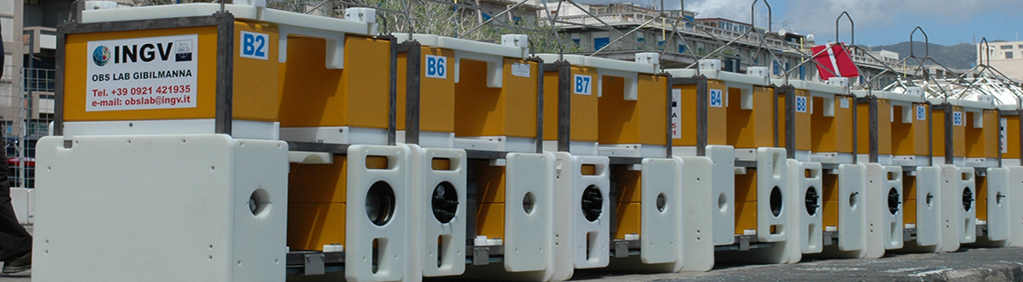
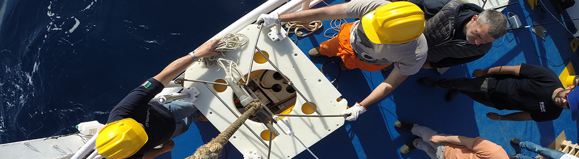
Thanks to the scientific collaboration between CNR-IGAG, CNR-ISMAR, INGV, and Sapienza University of Rome, and thanks to 10 new measuring stations provided by INGV, we will install 8 OBS/H (ocean bottom seismometers with hydrophone) and 2 geochemical sea bottom modules for a Fig.1 Structural Map of the Jonian Sea Area (Polonia et al. 2016)period of c. 12 months. This network of multiparametric stations is intended to:
- define, by seismic data analysis, the tectonic activity and the seismicity of some important faults in the western Ionian Sea;
- define the occurrence of gravitational phenomena (undersea slides) and their temporal relationship with seismic phenomena;
- characterize the possible venting processes (CH4, CO2, and O) from some mud volcanoes or venting sites identified along some important faults in the western Ionian Sea, in order to understand whether these degassing processes are activated by faulting and whether they can be considered as precursors of seismic events. The scientific approach to the above-mentioned themes is multidisciplinary and will employ seismological, geochemical, geomorphological, and geological-structural methods.
Aims
The main objectives of this study are seismic, tectonic (active), geomorphologic (underwater instability), and geochemical (geochemical precursors of seismicity). Specifically, the main objectives are three. Eight OBS/H and three geochemical modules (CH4, CO2, and O monitoring) provided by the INGV will be deployed and managed in scientific collaboration with the CNR-IGAG, CNR-ISMAR, and Sapienza University of Rome.
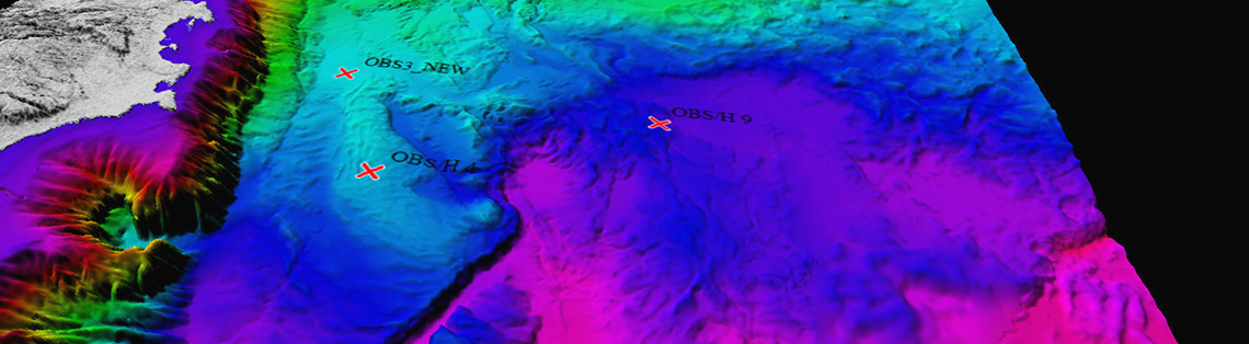
Objective: The first objective is to deepen the understanding of the tectonic and seismic activity of some multi-kilometer length faults recently identified in the western Ionian Sea by reflection seismics (Polonia et al., 2016a and references therein). To achieve this goal, 8 OBS/H will be deployed for c. 12 months at the Ionian seabottom, conveniently located near these faults. The main expected result is the improvement of the location of seismic events occurring in the Ionian Sea for the detection of tectonic structures. In other words, it is expected to be able to elaborate a new map of the seismic phenomena of the study area (Ionian). Regarding the detection capacity of the seismometers in terms of magnitude, the minimum recordable magnitude is M = 0.4 (Sgroi et al., 2007).
Objective: The second objective is to understand whether the mud volcanoes or venting structures identified in the vicinity of the above-mentioned faults (Panieri et al., 2013; Polonia et al., 2016a) presently constitute active degassing structures and whether this degassing is related (cause-effect relation) with the tectonic-seismic activity of the investigated faults. It is a primary goal, in particular, to define possible geochemical precursors of seismic events. To achieve this goal, two geochemical modules will be deployed for the duration of the project (12 months), suitably located near the investigated faults. The modules will record the emission of CH4, CO2, and O and the data obtained will be temporally and spatially compared and correlated with seismic signals recorded by the eight OBS/H. The data recorded by the geochemical modules located at the bottom of the sea will also be compared with the data recorded by the CTD rosette along the water column during both sea-going and recovery.
Objective: The third objective is to understand whether the continental margins of eastern Sicily and southern Calabria are subject to submarine gravity movements and if such movements can be in a cause-effect relationship with earthquakes of low magnitude. To achieve this goal, seismic signals of 8 OBS/H will be analyzed. From these data, it will be possible to detect both earthquakes and seismic signals associated with submarine landslides and their locations. The temporal succession of seismic and landslide events and their location will provide contributions to understanding the cause-effect relationships between earthquakes and landslides. Finally, the analysis of the Ionian Sea mareographic data will provide information on the possible development of tsunamis (even small ones) generated by earthquakes, landslides, or both. The intersection of such data can therefore significantly improve the knowledge of the cause-effect relationships between earthquakes, landslides and tsunamis in the Ionian area.
Argnani et al, 2009, doi:10.1029/2009GL037332.
Billi et al, 2008, doi:10.1029/2008GL033251.
Billi et al, 2009, doi: 10.1029/2009GL037499.
Billi et al, 2010, doi: 10.1785/gssrl.81.6.907.
Doglioni et al, 2012, doi: 10.1038/srep00970.
Favali and Beranzoli, 2009, doi: 10.1016/j.nima.2008.12.214.
Gutscher et al, 2017, doi: 10.1016/j.epsl.2016.12.020.
Panieri et al, 2013, doi: 10.1016/j.margeo.2012.11.003.